Taking in the beauty of a Japanese temple.
Valleys, Mountains, and Snow
The first day had been a long day, but interesting, and the trip along highways and byways had already shown me a lot of diversity that is Japan. Following our day-long adventures in Matsuyama we prepared for the next day, when my plan included a drive along highway 494 from Matsuyama toward Niyodogawa, but then taking highway 439 to Otoyo and beyond – the trek through the valleys and then eventually along the mountain range looked appealing, because half-way between Otoyo and Kamiyama, just before Mount Tsurugi, is an attraction called the Oku-Iya Double Vine Bridge, something which I had seen published somewhere, and thought would be a great place to see. The day would be long, and the final plan was to end up in Osaka for the night – a total distance of around 300km, but doable in a day and still take in some sights. And Kobe beef was a thought at the back of my mind as well, since we would have to pass through…
The drive through the valley was wonderful, the weather was great, and traffic moved along nicely. We slowly crept up higher into the foothills before taking the left turn onto highway 439. The mountain range rose up slowly, and the views into the valleys on either side were wonderful. There was the odd patch of snow that clung to the hillsides, but I paid no attention as it seemed that the weather and the roads were great, and there was nothing to worry about. We continued up a winding road, when coming around one corner the view up ahead was a little less promising.

The long, slippery road across the mountains
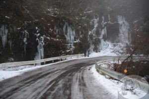
More snow had accumulated on the road, and as I turned into an upcoming curve, I could feel the car slide a bit, and I realized that it wasn’t just slush on the road, but also a thin patch of ice, and right in the middle of the curve the road dipped slightly, and the slush was thicker; I kept up speed and slowly tried to speed up, hoping I had enough forward momentum to get through the patch. A few sweaty seconds passed, and we had come through. I moved on a short way, then found a place to park safely for a few moments.
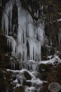
The icicles attached to the mountain side where a waterfall had flown were quite interesting and photo-worthy. I was a bit concerned about the rest of my chosen route, but decided that in for a penny, in for a pound, and we would proceed along the mountain as turning back would be a damper on the plan.

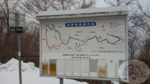
The choice – to go left, or to go right? Either direction was indecipherable
Choices at intersections…
The road dropped down again, and there was traffic flowing in both directions, and the views were interesting, and so we moved on. The sky became cloudy. The road had a slight dusting of snow, which grew in thickness as we moved on. There were tracks in the snow, yet no car met us coming from the opposite direction – I should have read those signs as warnings, but kept crawling along. All thoughts of the vine bridges had been erased from my thoughts, and I focused only on what was ahead of me. We came to a three-way intersection with a physical sign, the first I had seen for a while, and I was thankful, as my GPS was no longer of any use. Yet when I had parked and walked over to the sign, it was impossible to figure out what the best choice would be. I walked a short distance to the left and looked at the snow and tracks in the snow before walking down the right-hand track and studied the road and snow and tracks. After another few minutes of debate, we decided to press on, not go back, as going back was probably as bad a choice as going forward. It just seemed that more traffic had gone to the right than the left… We slipped and slid through the snow, speeding up at crucial moments to burst through extra thick layers, at all times keeping both hands on the steering wheel, and quietly hoping that soon we would be moving down the mountain.

Icicles clinging to the mountain – it was cold
Night time, snow, and driving on fumes
The tracks in the snow were less now, but there had been no visible turn-offs. Moving along at a slow pace I finally had GPS on my phone again, and there was a town indicated somewhere in the distance. I breathed a sigh of relief and then looked at the fuel gauge and wished I had kept my sigh to myself. The gauge was slipping dangerously close to the empty mark, and I had no idea how much further the car would go once the gauge read empty – I had heard that Japanese vehicles only have about 2 liters in them once the gauge reads empty. A quick calculation left me hoping that the town was closer than 25 kilometers, and had a gas station. It was dark outside now, and the road was covered in more snow, and we had not met any on-coming traffic for more than an hour. In the distance I spotted a few lights and hoped they indicated the outskirts of some town or another. There was a fork in the road, and according to my GPS I should head left. A big sign pointed to something, and I figured it would be the town. We turned left. The headlights picked out a road that rose up, and I gave a little bit extra gas to move the vehicle forward and up, but just as we crested the hill, pillars rose up on both sides of the track, and a roof of some sort appeared above, and a wall blocked the way ahead. I stared ahead for a few moments, then proceeded to turn the car around. As I was backing into a parking spot and then spun around to look ahead again I could see a chair lift and a sign for ski rental – we had ended up at Shikoku Ski Resort.
To Be Continued next entry…
